
Why is it important to provide complete land management documentation for examination?
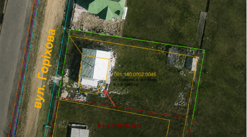
At first glance, it may seem that for a land surveying forensic examination, it is sufficient to provide a plan or the coordinates of the boundary turning points of a land plot.
However, in practice, it is precisely an incomplete set of documentation that often leads to incorrect conclusions.
A case from my own practice clearly demonstrates this.
Now, please read the following carefully and look closely at the illustration:
- Yellow – the boundaries of the land plot according to the land management documentation.
- Green – the actual location of the boundaries.
- an error in determining the coordinates;
- incorrect coordinate transformation;
- a technical error made during the preparation of the land management documentation, etc.